LMT 3 Magnetotelluric Instruments is independently self developed which utilizing the latest electronic technology. It improves data processing algorithms and integrates the advantages of mainstream Magnetotelluric Instruments, addressing the issue of insufficient AMT detection depth by broadening the working frequency range. The equipment is highly integrated, portable, efficient, and reliable.
Advantages
Unique Three-Band Simultaneous Sampling: This instrument is equipped with 12 built-in channels. In the scenario of both electric and magnetic field collection, each component is divided into high, medium, and low frequency bands for simultaneous collection. This significantly enhances the efficiency of data collection, with the three-band simultaneous collection more than doubling the efficiency compared to similar electromagnetic systems.
Unique Frequency Band Optimization: Different analog signal pathways are designed to optimize for the characteristics of signals in different frequency bands. The low frequency band eliminates power frequency interference, the medium frequency band enhances the resolution of weak signals in the 1-3KHz dead band, and the high frequency band completely eliminates low-frequency interference, effectively extracting the signal-to-noise ratio of signals above 10KHz. This ensures that signals within a certain frequency band are not interfered with by signals from outside the band, achieving optimal overall data quality.
Unique Continuous Collection and Real-Time Calculation: The processing phase employs the latest low-power processors and optimized calculation algorithms, enabling continuous data collection and real-time calculations. It can display single-point time series, power spectrum, apparent resistivity, and other data in real-time, facilitating the on-site identification of anomalies, and avoiding extensive data storage and complex post-processing.
Unique Wide-Band Magnetic Sensor: The instrument uses a unique wide-band magnetic rod, with a single rod capable of collecting data across a frequency range of 1Hz to 100KHz. A single magnetic rod can perform ranges within a radius of up to 3km, ensuring minimal shallow blind spots, and meeting the majority of engineering and mineral exploration needs.
Unique Calculation Algorithm: Based on a foundation of extremely high stacking times, a multi-dimensional dynamic robust intelligent estimation algorithm is used. This algorithm can extract the most reliable data from a vast dataset, enhancing the resolution of weak signals, eliminating random interference, and increasing data stability.
High Integration: The software and hardware are entirely designed and developed in-house, with signal conditioning, data conversion, collection control, and data computations all integrated onto a single circuit board. There are no plug-in cards, preventing issues such as loosening due to transport or vibrations that could cause the instrument to fail to start or signals to become chaotic, effectively reducing the failure rate. The system integrates the collection circuit, battery, and signal amplifier, with a high degree of integration; the built-in battery ensures more than 10 hours of continuous operation without stopping, meeting the needs for all-day field use.
High Compatibility: The system can export data in EDI or Z file formats, compatible with other common data processing software on the market.
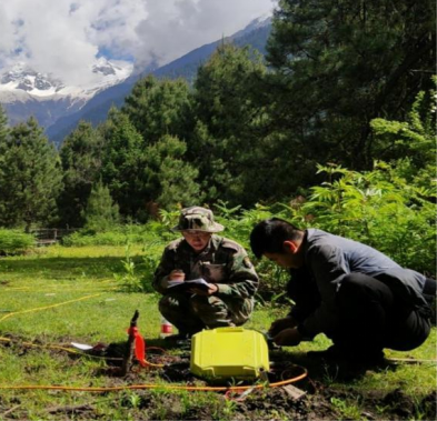
High Portability: A tablet or smartphone is used as the main control unit, with an app to control the instrument, display waveforms, and calculate results. After setting up the collection task and confirming the signal is normal, the connection can be disconnected without affecting the operation of the instrument. This greatly enhances portability, ease of use, and stability.
Applications
Oil and Gas Engineering: Shallow petroleum and natural gas exploration
Structural: Fracture zones, structural surveys
Coalfield: Coalfield stratification surveys and mined-out area investigations
Mineral: Metal mineral exploration
Hydrology: Groundwater, geothermal investigations
Karst: Karst cavity surveys
Geological Survey: Bedrock investigations for dams, railways, bridges, etc.
Geological Hazards and Environment: Geological hazards, environmental surveys
Urban: Urban active fault investigations
Specifications
Frequency Optimization | Divided into high, medium, and low frequency bands for simultaneous collection, with specific optimizations made for the signal characteristics of different frequency bands. |
Channel Number | 12 channels; (4x3 channels, with EX, EY, HX, HY each being split into high, medium, and low frequency bands for simultaneous collection). |
ADC | 24-bit for medium and high frequencies, 32-bit for low frequencies. |
Data Computing | Utilizes low-power, high-performance processors with optimized processing algorithms for continuous data collection and real-time computation. |
Frequency Range | 1~100KHz, filtering out direct current and radio frequency interference. |
Stacking Times | Low frequency>=16 times/min, |
Data Transmission Method | Wireless network WIFI transmission. |
Instrument Control | Controlled by an Android tablet or smartphone app. After sending the collection command, the instrument can work independently from the app. |
Data Display | Real-time display of single-point frequency data and multi-point resistivity profiles. |
Data Format | R file (proprietary), EDI file or Z file format (general). |
Gain | First stage:Electric channel 1,10; Magnetic channel 1,10,100; |
Input Impedance | 4GΩ. |
Power Source | Built-in lithium battery, 12v charging. |
Power Consumption | 10W, low power consumption, equipped with a lithium battery, capable of over 10 hours of use on a single charge. |
Operating Temperature | -20~70℃. |
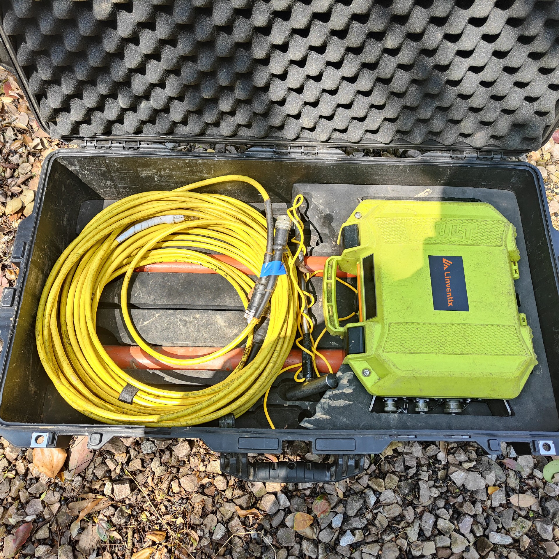
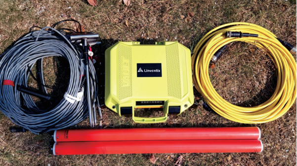
System Total Weight | System total weight 20kg; Total transportation case weight 25kg. |
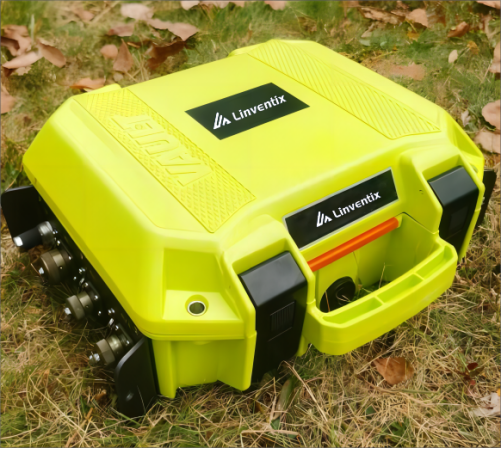
LMT3 Host
The LMT3 Host is a high-integration, portable, intelligent, and high-performance geoelectromagnetic host. It integrates all electronic circuits, including signal conditioning circuits, data conversion circuits, acquisition control circuits, and processing and computing systems, onto a single motherboard. This integration results in a device that is compact, has stable performance, and low failure rates. The instrument features a fully enclosed black box design, with a built-in Beidou positioning system and lithium battery. It uses a WIFI connection, allowing for real-time monitoring of the instrument's status, configuration of parameters, and display of data results through smartphones or tablets.
Advantages
The device features multiple channels, with an internal collection of 12 channels, each component divided into high, medium, and low frequency bands for simultaneous collection.
It has built-in multi-band analog filtering and conditioning circuits, optimizing each frequency band separately according to the characteristics of the signals in each band.
High precision data converters are used, with mid-to-high frequency utilizing a 24-bit ADC and low frequency employing a 32-bit ADC.
It features a high-performance low-power processor, capable of high-speed computations under low power consumption to meet the requirements for field portability.
It continuously collects time-series data, involving all time-series data in calculations for real-time processing without occupying collection time, thereby maximizing the use of collection time to obtain the maximum amount of raw data.
The device boasts high collection efficiency, with a large number of stacking operations and a large data volume, capable of accomplishing 16 low-frequency stackings per minute; 240 medium-frequency stackings; and 3000 high-frequency stackings. Its multi-dimensional dynamic Robust algorithm allows for the real-time extraction of the most reliable data from a large dataset, surpassing the post-data processing methods used by other devices.
An internal algorithm for real-time apparent resistivity calculation negates the need for indoor computations.
The main unit can wirelessly connect to a mobile terminal via WIFI, allowing for real-time monitoring of the device status, setting of device parameters, and display of data results and resistivity profiles.
The device can operate independently. Once the collection task is set, there is no need to connect to a mobile terminal, and the device can complete data collection and computation independently. It has an integrated design with a built-in battery, collection board, and processing system; no external preamp or battery is needed. It features a single motherboard with a high degree of integration.
The device has low power consumption, with a single charge lasting for more than 10 hours of collection, sufficient for a full day of field data collection using a single built-in lithium battery.
It supports the built-in Beidou positioning system, capable of synchronizing clocks and recording instrument coordinate information.
It comes with a feature to measure ground resistance.
It is compatible with magnetic bars from other manufacturers.
Specifications
Project | Specifications |
Channel Count | 4x3 channels (EX, EY, HX, HY each component is divided into high, medium, and low three frequency bands independently) |
Frequency Range | 1~100KHz, filtering out DC and RF interference |
ADC | High and medium frequency use 24 bits, low frequency uses 32 bits |
Data Calculation | Continuous collection, multi-dimensional dynamic Robust estimation |
Stacking Times | Low frequency: ≥16 times/min Medium frequency: ≥240 times/min High frequency: ≥3000 times/min |
Gain | First stage: Electric channel 1,10; Magnetic channel 1,10,100 Second stage: Both electric and magnetic channels are 1,10,100 |
Input Impedance | 4GΩ |
Instrument Control | Via Android tablet or smartphone app |
Data Transmission | Wireless network WIFI |
Data Format | R file (proprietary), can export to EDI file or Z file format (universal) |
Power Supply | Built-in lithium battery, 12v charging |
Power Consumption | 10W, low power consumption, with built-in lithium battery, can be used for more than 10h on a single charge |
Operating Temperature | -20~70℃ |
Weight | 5kg |
Dimensions | 340x295x152mm |
Data Acquisition Control Software
This data acquisition control software is a mobile APP designed for the LMT3 instrument, allowing users to set acquisition parameters via a wireless network, monitor the instrument's status in real time, and display data such as time series, power spectrum, and apparent resistivity. The software is developed for the Android platform and can run on Android tablets or smartphones.
Advantages
Instruments can be connected through a wireless network for remote control and high-speed synchronous data display.
Convenient and concise to set acquisition parameters.
Real-time display of time series data, monitoring of signals across channels, and timely detection of setup issues.
Real-time display of apparent resistivity data, facilitating the monitoring of data quality.
Capable of displaying profile data, with the option to display apparent resistivity or a quasi-two-dimensional profile from one-dimensional inversion.
Compatible with Android tablets or smartphones.
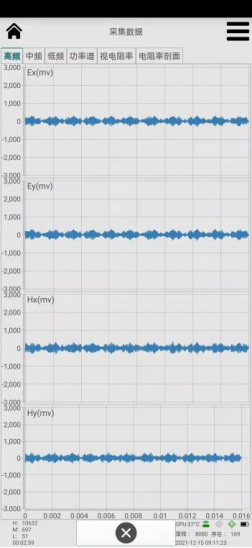
High-frequency Time Series
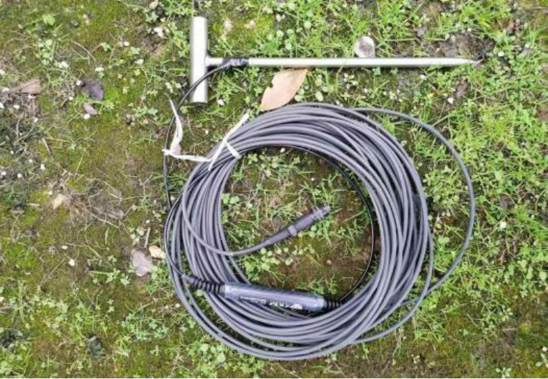
AS05 Magnetic Field Sensor
Utilizing the latest chip and circuit design, and with an internal structure designed to fit within a shorter length, it achieves a wide frequency range of 1Hz to 100KHz, while reaching performance indicators of extremely low noise.
Specifications
Frequency Range | 1Hz~100KHz |
Noise | 1.0*10^-6 nT/√Hz @ 1000Hz |
Supply Voltage | 9V to 15V |
Supply Current | 25mA |
Weight | 2.1kg |
Dimensions | Diameter 45mm, Length 720mm |
Waterproof Rating | IP67 |
Operating Temperature | -20~70°C |
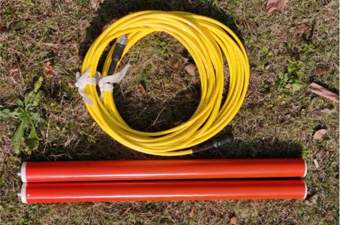
EAB18 with Buffered Amplifier Electrode Wire
Innovative Buffered Amplifier Electrode Wires that utilize stainless steel electrodes can achieve low high-frequency losses while also measuring grounding resistance. This overcomes the shortcomings of traditional buffered electrode wires, which cannot measure grounding resistance or assess grounding conditions in the field.
Advantages
Buffer amplification, reduces high-frequency signal attenuation.
Compatible with host device for measuring ground resistance.
Can connect to stainless steel electrodes, generally does not require additional watering under normal conditions.
Specifications
Frequency Range | 1Hz~100KHz |
Supply Voltage | +/- 9V to +/- 15V |
Weight | 0.5kg (excluding stainless steel electrodes) |
Length | 18m |
Waterproof Rating | IP67 |
Operating Temperature | -20~70°C |
Cases
Karst
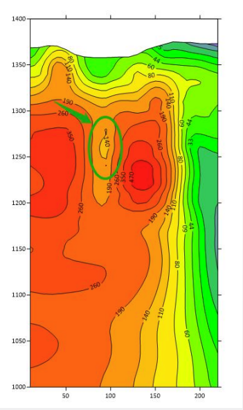
LMT3 Magnetotelluric Instrument Two-dimensional Resistivity Inversion Profile Map
As shown in the figure, a low-resistance depression anomaly area was discovered between points 90 and 110, and a low-resistance anomaly in the form of a georesistive closed loop was found within the elevation range of 1250 to 1280 meters. A drilling hole was arranged at point 100 to verify the anomaly, and the drilling revealed that the anomaly was a karst cave.
Hot Springs
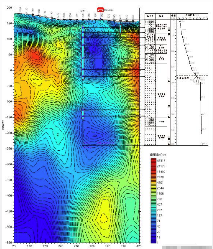
LMT3 Magnetotelluric Instrument Two-dimensional Resistivity Inversion Profile Map

Test Scenario
The hot springs develop in granite and are controlled by fault fractures. The low resistance areas in the diagram are due to water content in the fractured rocks, which matches well with the water outflow locations in the boreholes.